
Hallin Fell from Martindale
A short, rewarding walk with maximum views for minimum effort, set above the quieter eastern shores of Ullswater.
Route Info: 3 miles (4.5km) | Moderate | 240m ascent / descent | allow 1½-2hrs
Start: St Peter’s Church, Martindale
When we once told a local character we’d been up Hallin Fell, she remarked approvingly: “Ah yes, maximum views for minimum effort” – and that’s exactly how this short walk feels, despite the steep, grassy ascent to the perfectly situated summit. Beginning and ending by the tiny church at Martindale (which is well worth a poke around), this short but immensely rewarding loop offers magnificent Ullswater views before descending to the lakeshore and returning via woodland paths and open fellside.
Highlights
Route description
Safety & practical information
Terrain: Well-defined grassy and lakeside paths throughout, though the descent towards Ullswater can be steep and occasionally slippery in wet conditions.
What to take: Map (OS OL5 – English Lakes NE), compass, waterproof clothing, warm layers, sturdy walking boots and sufficient food and water. A headtorch and basic first-aid kit are also recommended.
Other info: Although short, the route includes exposed fellside and lakeshore sections. Paths may be muddy after rain, and livestock may be present on the open fell.
Start: St Peter’s Church, Martindale
When we once told a local character we’d been up Hallin Fell, she remarked approvingly: “Ah yes, maximum views for minimum effort” – and that’s exactly how this short walk feels, despite the steep, grassy ascent to the perfectly situated summit. Beginning and ending by the tiny church at Martindale (which is well worth a poke around), this short but immensely rewarding loop offers magnificent Ullswater views before descending to the lakeshore and returning via woodland paths and open fellside.
Highlights
- Superb summit panorama over Ullswater
- A classic Wainwright felltop (388m)
- Beautiful lakeshore walking along Ullswater Way
- Peaceful woodland paths through Hallinhag Wood
- A perfect short outing, achievable in under 2 hours
Route description
- From the small parking area beside St Peter’s Church at Martindale, follow the obvious grassy path heading north-west up the open fellside. The path climbs steadily, with increasingly impressive views opening out – both behind you back into Martindale, and then across Ullswater and the surrounding fells.
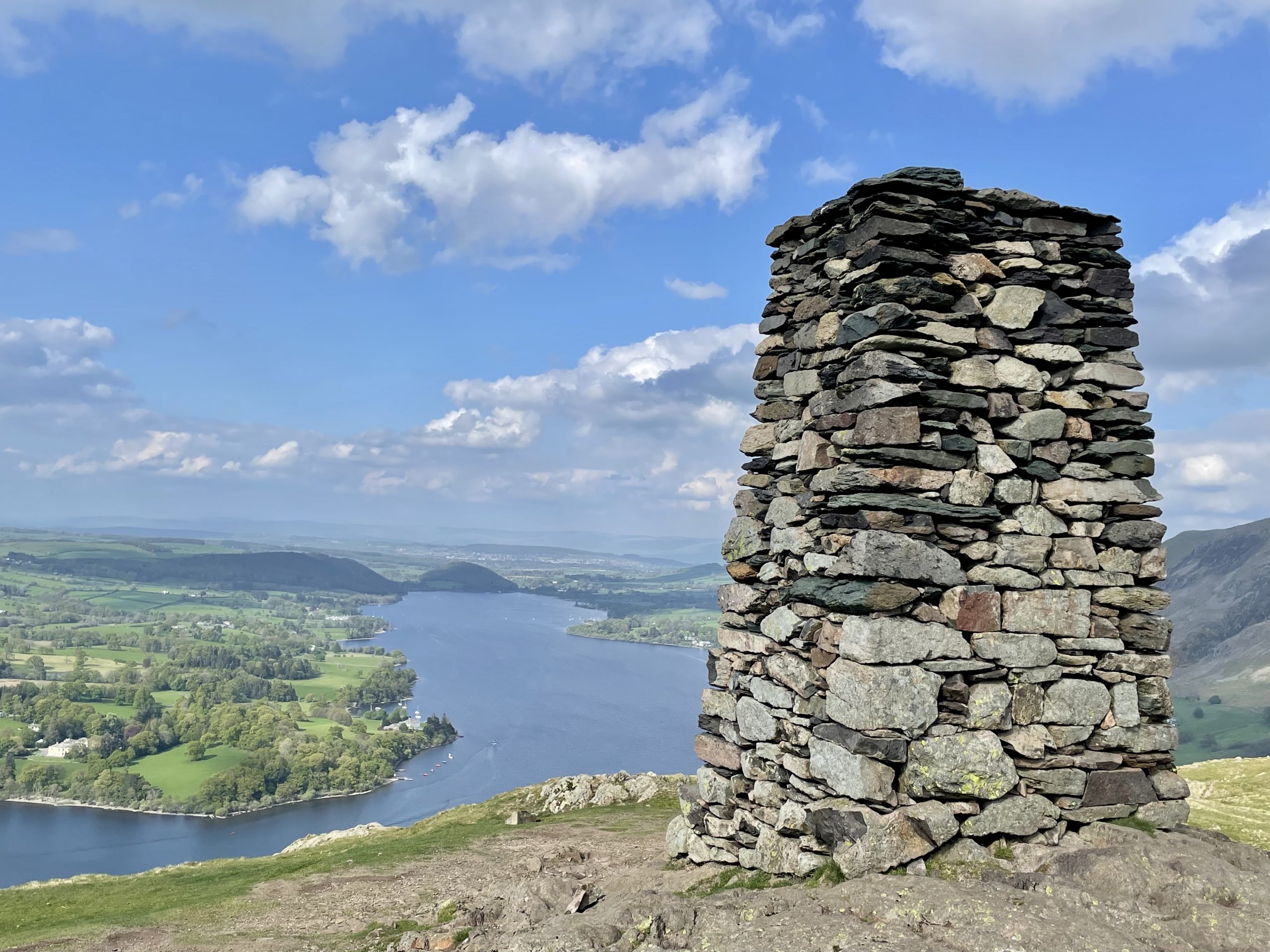
- After around 20-25 minutes of ascent, the gradient eases as you approach the broad summit ridge of Hallin Fell (388m), marked by a prominent cairn. Despite its modest height, the panorama here is superb, with Ullswater stretching away to the north-west and the higher fells of the Helvellyn range rising dramatically beyond.
- Continue beyond the summit in an easterly direction, following the clear path as it begins to descend the far side of the fell. The path soon steepens as it drops towards the lakeshore.
- On reaching the shoreline path, part of the Ullswater Way, head north and then west as you pass beneath Geordie’s Crag and then reach Kailpot Crag, a favourite wild swimming spot on warmer days where the more daring like to jump into the lake from a rocky height.
- Continue along the lovely shoreline path, much of it running through Hallinhag Wood. There are various small pebble beaches along the way which are good places to pause and take in the view.
- After walking along the shore for 20 minutes or so, turn inland just before reaching Sandwick Bay. The junction is easily missed and lies just before a gate leading to the bay. From here, head up through woodland beside a drystone wall before joining the elevated path along Hallin Bank, with views over Ullswater and along the valleys of Boredale and Howe Grain.
- Near the end of Hallin Bank, turned left to join a path above Hause Farm which brings you back to the start of this short but undeniably beautiful circuit.
Safety & practical information
Terrain: Well-defined grassy and lakeside paths throughout, though the descent towards Ullswater can be steep and occasionally slippery in wet conditions.
What to take: Map (OS OL5 – English Lakes NE), compass, waterproof clothing, warm layers, sturdy walking boots and sufficient food and water. A headtorch and basic first-aid kit are also recommended.
Other info: Although short, the route includes exposed fellside and lakeshore sections. Paths may be muddy after rain, and livestock may be present on the open fell.
Article | Walks