
Catbells & Derwentwater Walk
A classic Lake District fell walk with a short but rewarding climb and big, 360-degree views, returning along the shores of Derwentwater.
Route Info: 4.5 miles (7.5km) | Moderate | 370m ascent / descent | allow 2½-3hrs
Start: Hawse End car park, or from Keswick take the Launch boat across Derwent Water
A classic Lake District fell walk with a short but rewarding climb and big, 360-degree views, returning along the shores of Derwentwater. One of the Lake District’s most popular and rewarding short walks, Cat Bells offers a fine introduction to fell walking, with superb views over Derwentwater and the surrounding fells. Starting from Hawse End on the western shore of the lake, the route climbs steadily to the summit before descending to the lakeshore and returning along peaceful woodland paths. Easily reached from the hotel by car, or by taking the Keswick launch across the lake, it makes an ideal half-day outing in one of the area’s most beautiful settings.
Highlights
Route description
Safety & practical information
Terrain: Well-defined fell paths throughout, with some steeper, rocky sections on the ascent. A few short sections require hands for balance. The lakeshore paths are generally easy but can be uneven in places.
What to take: Map (OS OL4 – English Lakes NW), compass, waterproof clothing, warm layers, sturdy walking boots and sufficient food and water. A headtorch and basic first-aid kit are also recommended.
Other info: This is a very popular route and can be busy, particularly in good weather. Care is needed on the steeper sections, especially in wet conditions. The ridge is exposed to wind, and paths can be slippery after rain.
Start: Hawse End car park, or from Keswick take the Launch boat across Derwent Water
A classic Lake District fell walk with a short but rewarding climb and big, 360-degree views, returning along the shores of Derwentwater. One of the Lake District’s most popular and rewarding short walks, Cat Bells offers a fine introduction to fell walking, with superb views over Derwentwater and the surrounding fells. Starting from Hawse End on the western shore of the lake, the route climbs steadily to the summit before descending to the lakeshore and returning along peaceful woodland paths. Easily reached from the hotel by car, or by taking the Keswick launch across the lake, it makes an ideal half-day outing in one of the area’s most beautiful settings.
Highlights
- A classic Wainwright summit (Cat Bells – 451m)
- Superb views over Derwentwater and Keswick
- Enjoyable, hands-on sections on the ascent
- A scenic lakeshore return via Brandelhow
- Combine with a boat trip on Derwent Water
Route description
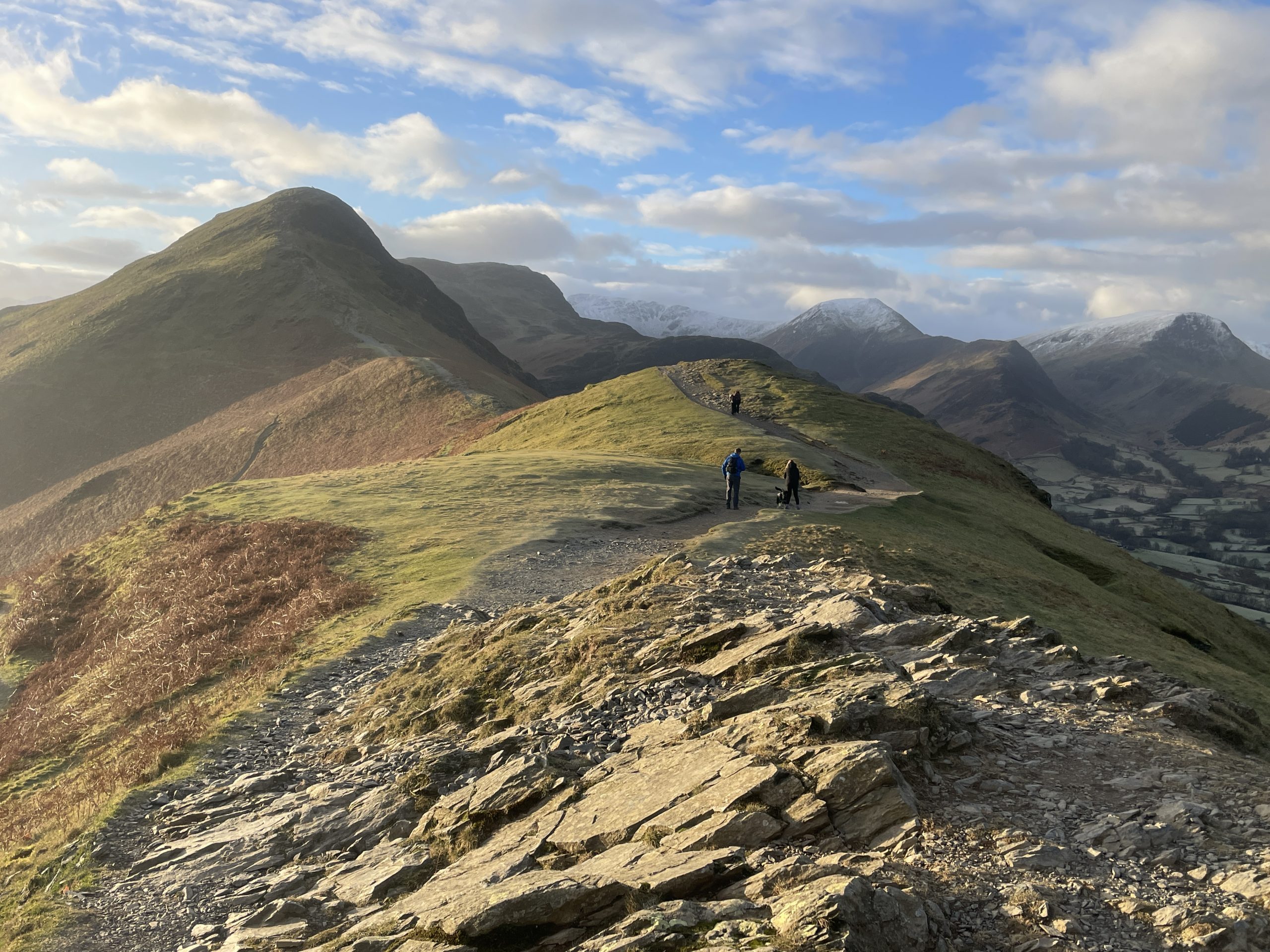
- From the parking area or lakeside jetty at Hawse End, follow the clear path up onto the northern end of the Cat Bells ridge, just above the road. You soon begin to zig-zag up the fellside.
- The path climbs steadily up Skelgill Bank (338m), with views quickly opening out over Derwentwater. Continue along the ridge, before reaching a few short, hands-on sections across craggy terrain – though these are straightforward and well-used.
- After a final pull, reach the summit of Cat Bells (451m), marked by a cairn and offering wide-ranging views across the lake and toward Keswick, the Skiddaw massif and Blencathra.
- Continue south along the ridge, descending gently to the broad col at Hause Gate, where several paths meet.
- From Hause Gate, descend the steep but obvious path bearing left (south-east). Before reaching a plantation of conifers, you join the main terrace path, continuing downhill before following a drystone wall to reach the road.
- Turn left along the road, but after around 300m head right down a track and then footpath through Manesty Park to the lakeshore at Brandelhow Bay.
- Here join the lakeshore path and follow it north through woodland, passing High Brandelhow Landing and then Low Brandelhow.
- Continue along the pleasant shoreline path until you return to Hawse End, completing the circuit.
Safety & practical information
Terrain: Well-defined fell paths throughout, with some steeper, rocky sections on the ascent. A few short sections require hands for balance. The lakeshore paths are generally easy but can be uneven in places.
What to take: Map (OS OL4 – English Lakes NW), compass, waterproof clothing, warm layers, sturdy walking boots and sufficient food and water. A headtorch and basic first-aid kit are also recommended.
Other info: This is a very popular route and can be busy, particularly in good weather. Care is needed on the steeper sections, especially in wet conditions. The ridge is exposed to wind, and paths can be slippery after rain.
Article | Walks